News
SUSALPS-grazing experiment Brunnenkopfalm: Droneflight provides impressive insights in the initial Alm status as a basis for experimental re-grazing with Murnau-Werdenfelser cattle.
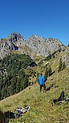
![[Translate to English:] 3D-Modell Brunnenkopfalm](/typo3temp/_processed_/d/1/csm_brunnenkopfalm_3dmodell_11508f5986.jpg "[Translate to English:] 3D-Modell Brunnenkopfalm")
Abandoned mountain pastures are valuable but threatened old agricultural landscapes characterized by high biodiversity. In close cooperation with farmers, Nature Conservation Authorities, the Ornithological Station in Garmisch-Partenkirchen, Forest Administrations, and Bavarian state farming advisors, SUSALPS scientists investigate effects of re-grazing of abandoned mountain pastures by the traditional and robust Murnau-Werdenfelser cattle species affects soil functions, biodiversity and feed value. This research is expected to result in recommendations for successful and sustainable re-vitalization of abandoned mountain pastures.
For this purpose, the Brunnenkopfalm mountain pastures in the Ammer mountains were successfully mapped by WWL Umweltplanung und Geoinformatik GbR via drone-based remote sensing on Sept 22, 2017, thereby providing a high-resolution 3D-model of the abandoned Alm and its current vegetation. These datasets serve as a reference for our future research.
The Drone flights were conducted with permission of the Government of Oberbayern, Higher Nature Conservation Agency.
-> Link to the interactive 3D-Model