News
Successful in a team: Field and remote sensing data
Remote sensing data - e.g. images from drones and satellites - offer the possibility to observe the landscapes on a larger scale. Instead of only having information for single locations, remote sensing data can be used to investigate various parameters and processes in the area. For example, the effects of drought periods on vegetation can be analyzed at the field, regional or global scale - depending on the used platform.
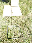
However, the time- and labor-intensive field work is still not superfluous, as it can be used to calibrate and validate the remote sensing data. Within the SUSALPS project, a dataset with field data on vegetation parameters in pre-alpine grassland was obtained. With the help of these data and the images from drones or satellites we are developing methods to create e.g. maps of the above-ground biomass and nitrogen content in the grassland vegetation. In order to enable other research groups to use these field data for the calibration and validation of their remote sensing models, the data set was deposited in a publicly accessible database and described in a scientific data article.