News
Start of the remote sensing experiment
Area-based information on the vegetation of grassland (e.g. biomass, nitrogen content) and on management are important for various applications, e.g:
- Determination of the grassland yield
- Calculation of nitrogen removal by plants
- Derivation of field-based nitrogen balances
- Determination of the fertilizer requirement
This surface information is also an important input for modeling in the SUSALPS project. The effects of climate change and grassland management on ecosystem services (e.g. soil functions, plant productivity and forage quality) are thus assessed at regional level.
In the second phase of SUSALPS we test how well we can derive biomass and nitrogen content in vegetation as well as management events (e.g. cut) from remote sensing data. For this, we investigate data from drones and satellites.
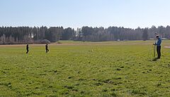
In order to develop and evaluate methods for the use of remote sensing data, we need field data. Within the framework of field campaigns, we measure the biomass and nitrogen content in various grasslands several times during the vegetation period. At the same time, we fly over the areas with a drone. In this way we can connect the field data with the remote sensing data.
The first drone flight was carried out on 29 March 2019.