News
Successful remote sensing field campaign in Franconian Switzerland
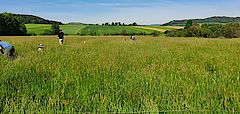
As part of the SUSALPS project, a field campaign to validate remote sensing analyses took place in Franconian Switzerland from May 16-19, 2022. In cooperation of KIT, DLR, WWL and the University of Bayreuth, a total of 30 grassland plots were sampled and investigated at three sites south of Bayreuth with respect to yield, quality and biodiversity of the plant community. The selection of the grasslands was intended to cover a wide range of different grassland management practices as possible and was carried out in close consultation with the respective farmers. During the same period, aerial photographs of the study areas were taken using drone aerial surveys, providing additional high-resolution information on biomass.
Preliminary initial results indicate that more intensive grassland management had a positive effect on biomass, whereas minimal use was associated with significantly higher species diversity. More detailed findings are expected after further analyses of the samples and a completed evaluation of the data. Linking the ground-based data obtained with drone aerial photography and satellite remote sensing data will allow large-scale estimates of grassland yields and biodiversity to be further improved. Such studies can contribute to grassland management adapted to the region and climate change, while optimizing the balance between economic efficiency and biodiversity.